
BBC Climate and Verify data journalism teams
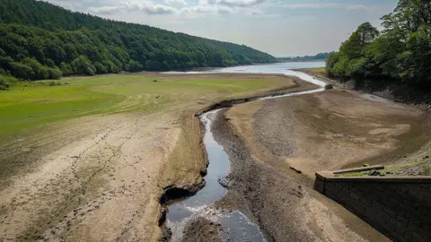 Getty Images
Millions of people in England are in regions hit by drought, and further parts of England are at risk of following if dry weather continues, the Environment Agency says.
Parts of eastern Scotland and west Wales are also being closely monitored amid low water levels, according to the water companies there.
So how is your area doing and how close are you to a drought? Here’s a look at what’s happening around the country, including our rain, rivers and reservoirs.
What is a drought and is there a hosepipe ban in my region?
There is no single definition of drought, but it is ultimately caused by a prolonged period of low rainfall, which has knock-on effects for nature, agriculture and water supplies.
A decision to declare drought is taken based on an assessment of current water levels and long-term weather forecasts.
It is a public sign that water companies might introduce restrictions on water use, such as hosepipe bans, if they aren’t already in place.
Areas with hosepipe ban areas don’t exactly match drought declarations, because plans to manage water vary between regions.
In England, the North West, Yorkshire, East Midlands and West Midlands are in drought, the Environment Agency says, as shown by the map below.
Most of the rest of the England is in a status of prolonged dry weather, the category below drought.

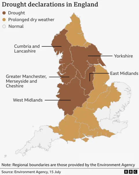
There are no official droughts currently in Northern Ireland or Wales, although Mid and South Ceredigion in west Wales are in “developing drought”.
Scotland does not declare droughts but monitors “water scarcity”. Parts of eastern Scotland are in “moderate” scarcity – the second most extreme category – which means there is “clear” environmental impact.
One of the driest springs on record
The main reason for these droughts being declared is the long period of low rainfall.
The UK had its sixth driest spring since records began in 1836.
So there has been less moisture to top up our rivers, reservoirs and rocks below the ground.
If that lack of rainfall continues for a long time, it can strain the water supplies that serve our homes and businesses.
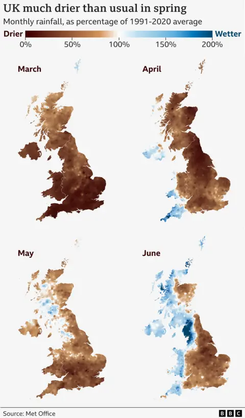
In June there was slightly more rainfall than average for the UK overall, but with a big difference between east and west.
The start of July was drier than usual, but more changeable conditions are forecast for the rest of the month.
Rainfall amounts over the coming months will play a key role in shaping which other regions enter drought, and how quickly.
At the moment roughly average rainfall is expected between now and September, the Met Office says.
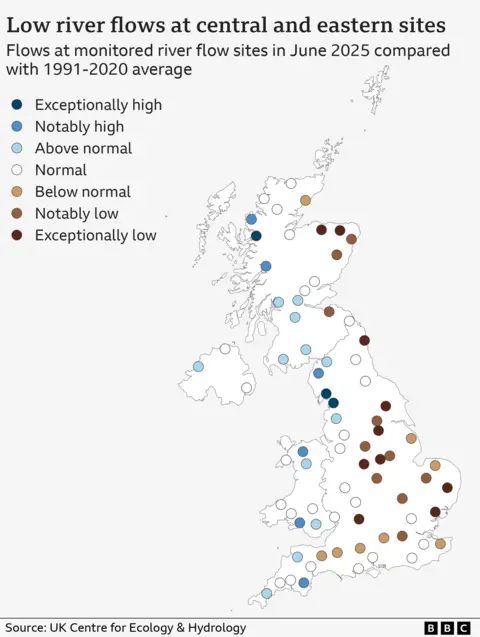
Drier rivers for most of the UK
That east-west divide in June rainfall is reflected in monitored river flows across the UK.
At the end of last month, river flows in western Scotland, Northern Ireland, Wales and north-west and south-west England were generally around their normal levels, or even above.
But river flows in many eastern, central and southern areas were about the same as – or even below – previous drought years of 1976, 2011, 2018 and 2022, said Lucy Barker, hydrologist at the UK Centre for Ecology and Hydrology (UKCEH).
Soils are also much drier than usual across large parts of the UK, particularly England, UKCEH data shows.
Dry soils harm plant growth, hitting ecosystems and crop production. This dried-out vegetation also brings a higher risk of wildfires.
Drier soils also warm up more quickly, which can amplify heatwaves.
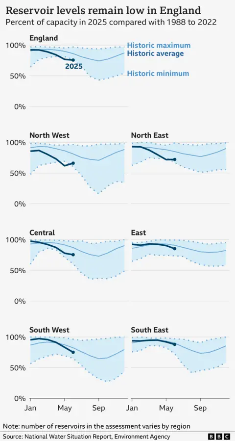
Exceptionally low reservoirs in north England
Reservoirs are a crucial part of water supplies in northern England, Scotland and Wales.
But England’s reservoirs are at exceptionally low levels for the time of year in records going back more than 30 years.
Reservoir levels in the North East and North West were near record lows for the end of June.
The main reason for this is, of course, the lack of rain, but a small number of reservoirs can be affected by other factors.
Normally at this time of year, Scottish reservoirs are 84% full. They are currently at 79%, according to Scottish Water.
In Wales, most reservoirs are around normal, Welsh Water said.
Reservoir levels are also about average in Northern Ireland, according to NI Water.
A more mixed picture underground
Much of south-east England relies more heavily on groundwater than reservoirs.
Groundwater originates as rainfall and is naturally stored beneath the surface in the pore spaces and fractures in rocks. Rocks that store lots of groundwater are called aquifers.
It accounts for a third of England’s water supply, though this is much higher in the south and east.
That is down to the UK’s varied geology, which affects how much water can be stored in the ground.
Water can flow more quickly through some rock types than others, sometimes taking years to respond to current conditions.
This is the case for parts of south and east England, which is why these regions are currently closer to normal.
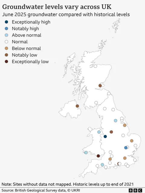
These groundwater stores “respond more slowly to changes in the climate than rivers, which is why they provide a useful buffer during periods of drought,” said Prof Alan MacDonald of the British Geological Survey.
It is why groundwater droughts in the South generally take a longer time to develop but can be longer-lasting if they do occur.
What are the consequences of the dry weather?
People and nature are already feeling the effects.
“It’s quite shocking that we are still only [in early] July,” Rachel Hallos, vice-president of the National Farmers’ Union, told BBC News at the beginning of the month.
“It’s like it’s the end of August when you look at the ground.”
With this little rain, farmers have had to get water onto their crops using irrigation.
That has made things more expensive for them and means there is even less water to go around.
There is widespread concern about the months ahead, Mrs Hallos added.
“What am I going to have to harvest? What am I going to have to feed my livestock over winter?”
And then there is the impact on wildlife.
A spokesman from the bird protection charity RSPB said that a big challenge has been making sure enough water is getting to key wetland habitats so that birds have safe places to nest.
“We need to be thinking about making our sites more resilient to climate change, as these periods of prolonged dry weather become the norm.”
And it’s not just water-loving birds that are having a hard time. Even in our gardens, common visitors like blackbirds can struggle to find worms and insects on our parched lawns, the RSPB says.
Is climate change to blame for drought?
Droughts are complex phenomena, driven by a mix of natural and human causes.
The Met Office expects the UK to experience drier summers on average in future as the world warms, though there has been no clear trend so far.
But rising temperatures can play a more fundamental role by sapping moisture from the soil via evaporation.
“A warmer atmosphere is thirstier for moisture and this can mean water in the soil, rivers and reservoirs are depleted more effectively, leading to more rapidly onsetting droughts, heatwaves and wildfires,” said Richard Allan, professor of climate science at the University of Reading.
But there are other factors that determine whether dry conditions lead to water shortages, including how we use water.
As part of plans to address water shortages, the government is planning nine new reservoirs for England by 2050, in addition to one under construction at Havant Thicket in Hampshire.
But the Environment Agency has warned that measures to tackle water leaks and control water demand – potentially including hosepipe bans and more smart meters – may be needed in England too.
Water companies in Scotland, Wales and Northern Ireland also said they were taking steps to secure future supplies.
Additional reporting by Dan Wainwright, Christine Jeavans and Muskeen Liddar

